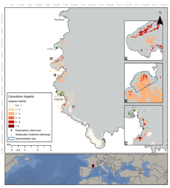
Using a DAPSIR-based method (Drivers – Activities – Pressures – State – Impact – Response), the analysis combines spatial datasets with expert-derived sensitivity scores to produce cumulative impact maps for priority habitats and species. These maps highlight where pressures such as fishing, shipping, anchoring, etc. overlap with high-value ecological areas.
A practical method for mapping pressures and impacts
The project team gathered data on local ecology and human activities such as fishing, anchoring, shipping, and coastal development, and combined them with local experts’ knowledge about how sensitive selected habitats and species are to pressures caused by those activities. By combining these datasets, we could see where human activities overlap with valuable nature, and where that overlap is strongest. This helped us identify hotspots where pressures stack up and may hinder conservation or restoration. Throughout the process, local partners were closely involved, reviewing the results and helping refine the maps so they accurately reflect the local situation.

Cross-site patterns: similar pressures, different impacts
Despite the geographical diversity of the demonstration sites (L’Albera, Vlaamse Banken, Macaronesia, Raet National Park, Cetacean Migration Corridor, Central Romanian Coast, Burgas Bay), it is found that a relatively small set of activities or pressures consistently drives ecological impact:
- Bottom-disturbing fishing
- Heavy maritime traffic (noise, collision risk, chemical pollution)
- Coastal development and dredging
- Anchoring and mooring in sensitive habitats
- Wastewater discharge and eutrophication
- Marine litter, including lost fishing gear
Importantly, these pressures often coincide spatially with ecological hotspots, creating persistent management conflicts.
From insights to solutions
The findings directly feed into the co-definition of conservation and restoration measures of WP3. The deliverable reflects on potential responses, ranging from awareness and compliance measures to habitat restoration and strengthened enforcement.
A foundation for coordinated, evidence-based action
Deliverable 3.1 provides a shared evidence base for the seven demonstration sites, supporting more targeted, effective marine conservation planning. By identifying the pressures that most hinder ecological recovery, it sets the stage for the next project phase: co-developing practical, locally supported measures that safeguard Europe’s marine biodiversity.